
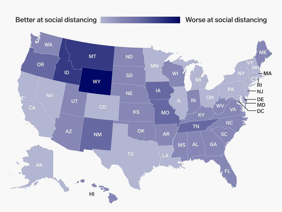
Tech Giants Apple and Google?s Social Distancing Maps?
Any smartphone can trace your location data at any time. Using that information, Google can suggest various restaurants or entertainment spots around you as well as other social amenities such as hospitals. Apple is also able to let you know where your phone is if you lose it by using location data.
It is through social distancing maps that Apple and Google are now monitoring how their users are following the strict guidelines amid the coronavirus pandemic. The Apple version launched only a few days ago, but Google?s app was started much earlier. The social distancing maps use mapping information from smartphone devices to monitor people?s movements in a bid to respond to the recent Covid-19 outbreak.?
Image credits: unsplash.com
Mobility Trends by Apple?
The social distancing maps version from Apple, Mobility Trends Reports, is the easiest to use between the two. It works by accessing anonymous data dispersed from routing requests. It makes a tally of the number of people walking, requesting driving services, or asking for transport routes in a day. It then displays this representation through a chart showing the number of these requests. The home page displays this information per country. The baseline of the social distancing maps is set to mid-January, which shows a clear picture of how this information compares with normal life activities. As expected, the lockdown procedures in some of the regions have seen numbers drop drastically as people do not move around much.
Having a steep slope means that there is a strict lockdown, or the people are following the guidelines much better. There is a search box feature at the top of the social distancing maps homepage that allows for looking up figures in different places across the United States and around the world. Apple has modified the data from its social distancing maps into categories such as driving, walking, and public transit for areas where Apple Maps has been whitelisted. For instance, Singapore established restrictions much earlier. Hence, the social distancing maps statistics show a steeper drop, Sweden took a much more lenient approach, and its curve is less steep as a result.??
These statistics, however, only show a fraction of the actual situation on the ground. The accuracy of social distancing maps data is emphasized by the reality of anyone walking on foot may not require directions as much as a person driving a vehicle. Seasons also account for these developments as people prefer to stay indoors during January and February, especially in regions that are usually in the winter period.??
?Community Mobility Reports by Google
Google?s social distancing maps version, the Community Mobility Reports,? has a page where it avails its statistical data. The framework is almost similar to Apple?s in terms of the general idea behind the project. However, Google doesn?t provide an online chart of the social distancing maps data like Apple does. Instead, it will prompt you to download a PDF for that particular region, city, or country you are interested in. The report is much more detailed than the Mobility Trends report.
The search box allows you to punch in the name of the country, city, or state anywhere around the globe. The approach employed by Google is a bit different, as their social distancing maps seek to show in detail where the majority of the population is spending time as opposed to the number of routing requests. It means that if your phone indicates that it is located in a residential area more often or a public location less frequently, the information will be shown on the report. You will see just how much people are adhering to strict measures.
Although the graphs from the social distancing maps do not depict as much detail as Apple?s, they accommodate several categories of locations that include grocery stores, pharmacies, recreation spots, transit stations, residential and workplaces. Now, there is a significant discrepancy between residents and workplaces over the past few weeks because of quarantine measures.??
The Map Tracking Security
Apple and Google have made it clear that even with this minor breach of privacy by their respective social distancing maps, their fundamental mission is always to protect user data and privacy. The data collected from the phone?s Maps service applications is randomized and attached to rotating identifiers. Therefore they do not keep a record of who you are or the trail of your movements.
Apple, for instance, has no provision for user location data. Google, on the other hand, has a disclaimer in its social distancing maps user agreement that clearly states that identity information, especially contacts, location, and movement, will never be disclosed at any moment in time.
There is hence no individually identifiable data attached to the reports from social distancing maps, and this is made possible by the considerable amount of data being exchanged between the servers regularly. Therefore, this data is used to monitor how much people are moving, and this will be very critical in spreading awareness about the spread and prevention of this global menace.